


6* COMCOM Thiers Dore et Montagne

Pierre Dabin
User

Length
6.4 km

Max alt
553 m

Uphill gradient
182 m
Km-Effort
8.9 km

Min alt
434 m

Downhill gradient
185 m
Boucle
No
Creation date :
2024-11-19 13:54:45.595
Updated on :
2024-11-19 13:59:33.375
1h09
Difficulty : Easy

FREE GPS app for hiking
 SityTrail
IGN / Geographical institutes
SityTrail Plus
The world is yours!
About
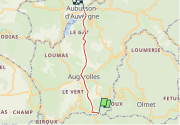
Trail Horseback riding of 6.4 km to be discovered at Auvergne-Rhône-Alpes, Puy-de-Dôme, Olliergues. This trail is proposed by Pierre Dabin.
Description
Route d'Artagnan MONTNEBOUT/AUBUSSON D'AUVERGNE
Positioning
Country:
France
Region :
Auvergne-Rhône-Alpes
Department/Province :
Puy-de-Dôme
Municipality :
Olliergues
Location:
Unknown
Start:(Dec)
Start:(UTM)
548940 ; 5061522 (31T) N.
Comments