


Ver dénivelé

APhilippe
User

Length
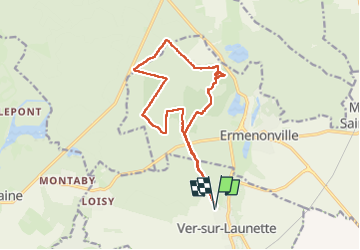
14.1 km

Max alt
129 m

Uphill gradient
159 m
Km-Effort
16.2 km

Min alt
86 m

Downhill gradient
159 m
Boucle
Yes
Creation date :
2024-11-20 08:05:13.796
Updated on :
2024-11-20 10:53:11.118
2h47
Difficulty : Medium

FREE GPS app for hiking
 SityTrail
IGN / Geographical institutes
SityTrail Plus
The world is yours!
About
Trail Nordic walking of 14.1 km to be discovered at Hauts-de-France, Oise, Ver-sur-Launette. This trail is proposed by APhilippe.
Positioning
Country:
France
Region :
Hauts-de-France
Department/Province :
Oise
Municipality :
Ver-sur-Launette
Location:
Unknown
Start:(Dec)
Start:(UTM)
476715 ; 5439645 (31U) N.
Comments