


CV sparbach 20-11-2024

maureengeorges
User
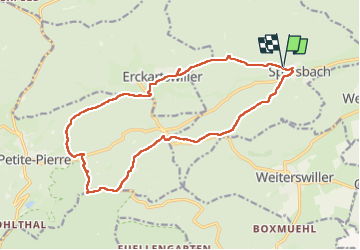

Length
16.8 km

Max alt
374 m

Uphill gradient
364 m
Km-Effort
22 km

Min alt
205 m

Downhill gradient
364 m
Boucle
Yes
Creation date :
2024-11-20 07:48:50.782
Updated on :
2024-11-20 15:41:13.781
5h07
Difficulty : Very difficult

FREE GPS app for hiking
 SityTrail
IGN / Geographical institutes
SityTrail Plus
The world is yours!
About
Trail Walking of 16.8 km to be discovered at Grand Est, Bas-Rhin, Sparsbach. This trail is proposed by maureengeorges.
Positioning
Country:
France
Region :
Grand Est
Department/Province :
Bas-Rhin
Municipality :
Sparsbach
Location:
Unknown
Start:(Dec)
Start:(UTM)
383353 ; 5415210 (32U) N.
Comments