


test rando

Doubotis
User ADMIN
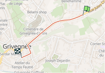

Length
874 m

Max alt
112 m

Uphill gradient
0 m
Km-Effort
987 m

Min alt
75 m

Downhill gradient
34 m
Boucle
No
Creation date :
2024-11-21 13:39:18.886
Updated on :
2024-11-21 13:41:33.903
3m
Difficulty : Very easy

FREE GPS app for hiking
 SityTrail
IGN / Geographical institutes
SityTrail Plus
The world is yours!
About
Trail Trail of 874 m to be discovered at Wallonia, Liège, Liège. This trail is proposed by Doubotis.
Description
ghhhhh
Positioning
Country:
Belgium
Region :
Wallonia
Department/Province :
Liège
Municipality :
Liège
Location:
Grivegnée
Start:(Dec)
Start:(UTM)
684929 ; 5611075 (31U) N.
Comments