


Tour du château de Lordat

loic09
User
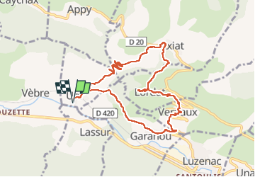

Length
10.8 km

Max alt
954 m

Uphill gradient
532 m
Km-Effort
17.9 km

Min alt
573 m

Downhill gradient
531 m
Boucle
Yes
Creation date :
2024-11-21 08:36:41.145
Updated on :
2024-11-21 13:50:53.843
3h27
Difficulty : Easy

FREE GPS app for hiking
 SityTrail
IGN / Geographical institutes
SityTrail Plus
The world is yours!
About
Trail Walking of 10.8 km to be discovered at Occitania, Ariège, Urs. This trail is proposed by loic09.
Positioning
Country:
France
Region :
Occitania
Department/Province :
Ariège
Municipality :
Urs
Location:
Unknown
Start:(Dec)
Start:(UTM)
396286 ; 4736461 (31T) N.
Comments