


Viols-en-Laval Cambous

gadafo
User
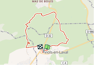

Length
8.8 km

Max alt
290 m

Uphill gradient
113 m
Km-Effort
10.3 km

Min alt
235 m

Downhill gradient
112 m
Boucle
Yes
Creation date :
2024-11-23 07:57:13.745
Updated on :
2024-11-23 08:16:47.15
2h20
Difficulty : Medium

FREE GPS app for hiking
 SityTrail
IGN / Geographical institutes
SityTrail Plus
The world is yours!
About
Trail Walking of 8.8 km to be discovered at Occitania, Hérault, Viols-en-Laval. This trail is proposed by gadafo.
Positioning
Country:
France
Region :
Occitania
Department/Province :
Hérault
Municipality :
Viols-en-Laval
Location:
Unknown
Start:(Dec)
Start:(UTM)
557738 ; 4844498 (31T) N.
Comments