


Demi tour du circuit des carriers

LydiaMich
User
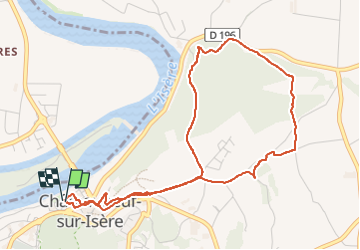

Length
5.3 km

Max alt
218 m

Uphill gradient
157 m
Km-Effort
7.4 km

Min alt
126 m

Downhill gradient
159 m
Boucle
Yes
Creation date :
2024-11-23 09:57:47.294
Updated on :
2024-11-23 11:19:40.252
1h21
Difficulty : Medium

FREE GPS app for hiking
 SityTrail
IGN / Geographical institutes
SityTrail Plus
The world is yours!
About
Trail Walking of 5.3 km to be discovered at Auvergne-Rhône-Alpes, Drôme, Châteauneuf-sur-Isère. This trail is proposed by LydiaMich .
Positioning
Country:
France
Region :
Auvergne-Rhône-Alpes
Department/Province :
Drôme
Municipality :
Châteauneuf-sur-Isère
Location:
Unknown
Start:(Dec)
Start:(UTM)
652628 ; 4986489 (31T) N.
Comments