


montalheyrac

lablaquiere
User
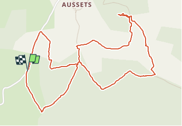

Length
3.6 km

Max alt
1239 m

Uphill gradient
130 m
Km-Effort
5.3 km

Min alt
1117 m

Downhill gradient
128 m
Boucle
Yes
Creation date :
2024-11-23 13:24:25.128
Updated on :
2024-11-23 14:41:50.148
1h02
Difficulty : Easy

FREE GPS app for hiking
 SityTrail
IGN / Geographical institutes
SityTrail Plus
The world is yours!
About
Trail Walking of 3.6 km to be discovered at Occitania, Lozère, Fournels. This trail is proposed by lablaquiere.
Positioning
Country:
France
Region :
Occitania
Department/Province :
Lozère
Municipality :
Fournels
Location:
Unknown
Start:(Dec)
Start:(UTM)
510655 ; 4961234 (31T) N.
Comments