


auvers st georges la butte blanche

olivieraron
User
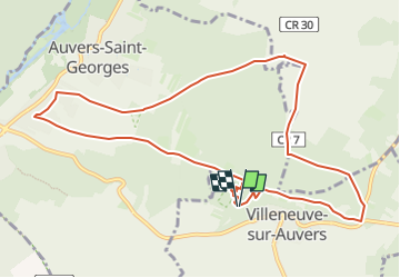

Length
10.6 km

Max alt
150 m

Uphill gradient
167 m
Km-Effort
12.8 km

Min alt
70 m

Downhill gradient
160 m
Boucle
Yes
Creation date :
2024-11-23 16:51:27.253
Updated on :
2024-11-23 17:12:10.528
2h54
Difficulty : Difficult

FREE GPS app for hiking
 SityTrail
IGN / Geographical institutes
SityTrail Plus
The world is yours!
About
Trail Walking of 10.6 km to be discovered at Ile-de-France, Essonne, Villeneuve-sur-Auvers. This trail is proposed by olivieraron.
Positioning
Country:
France
Region :
Ile-de-France
Department/Province :
Essonne
Municipality :
Villeneuve-sur-Auvers
Location:
Unknown
Start:(Dec)
Start:(UTM)
443963 ; 5369486 (31U) N.
Comments