


Terre et Etang Bousigues

leboucherdaniel
User
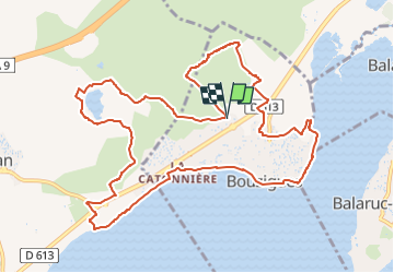

Length
13.4 km

Max alt
64 m

Uphill gradient
170 m
Km-Effort
15.7 km

Min alt
-4 m

Downhill gradient
172 m
Boucle
Yes
Creation date :
2024-11-24 10:29:13.434
Updated on :
2024-11-24 10:31:53.323
4h10
Difficulty : Easy

FREE GPS app for hiking
 SityTrail
IGN / Geographical institutes
SityTrail Plus
The world is yours!
About
Trail On foot of 13.4 km to be discovered at Occitania, Hérault, Bouzigues. This trail is proposed by leboucherdaniel.
Positioning
Country:
France
Region :
Occitania
Department/Province :
Hérault
Municipality :
Bouzigues
Location:
Unknown
Start:(Dec)
Start:(UTM)
552851 ; 4811468 (31T) N.
Comments