


notre dame du cayla versols

lablaquiere
User
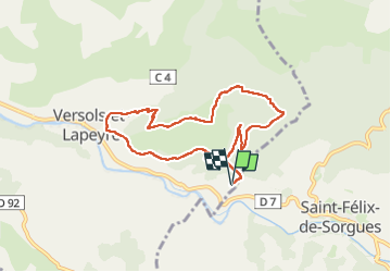

Length
8.6 km

Max alt
698 m

Uphill gradient
402 m
Km-Effort
14 km

Min alt
400 m

Downhill gradient
401 m
Boucle
Yes
Creation date :
2024-11-24 08:43:50.228
Updated on :
2024-11-24 11:35:30.559
2h20
Difficulty : Difficult

FREE GPS app for hiking
 SityTrail
IGN / Geographical institutes
SityTrail Plus
The world is yours!
About
Trail Walking of 8.6 km to be discovered at Occitania, Aveyron, Versols-et-Lapeyre. This trail is proposed by lablaquiere.
Positioning
Country:
France
Region :
Occitania
Department/Province :
Aveyron
Municipality :
Versols-et-Lapeyre
Location:
Unknown
Start:(Dec)
Start:(UTM)
497346 ; 4859380 (31T) N.
Comments