


Rando Sevelinges

yguillot
User
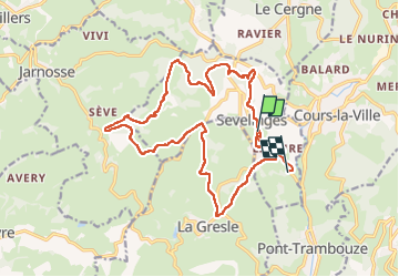

Length
20 km

Max alt
664 m

Uphill gradient
610 m
Km-Effort
28 km

Min alt
384 m

Downhill gradient
703 m
Boucle
No
Creation date :
2024-11-24 09:22:54.151
Updated on :
2024-11-24 13:24:51.887
4h00
Difficulty : Medium

FREE GPS app for hiking
 SityTrail
IGN / Geographical institutes
SityTrail Plus
The world is yours!
About
Trail Walking of 20 km to be discovered at Auvergne-Rhône-Alpes, Loire, Sevelinges. This trail is proposed by yguillot.
Positioning
Country:
France
Region :
Auvergne-Rhône-Alpes
Department/Province :
Loire
Municipality :
Sevelinges
Location:
Unknown
Start:(Dec)
Start:(UTM)
600265 ; 5105477 (31T) N.
Comments