


2024-11-24_22h48m00_DOC-20241124-WA0004.

Mariolebeno
User
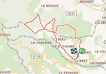

Length
9.7 km

Max alt
659 m

Uphill gradient
357 m
Km-Effort
14.4 km

Min alt
372 m

Downhill gradient
361 m
Boucle
Yes
Creation date :
2024-11-24 21:48:00.812
Updated on :
2024-11-27 07:51:02.694
2h20
Difficulty : Easy

FREE GPS app for hiking
 SityTrail
IGN / Geographical institutes
SityTrail Plus
The world is yours!
About
Trail Walking of 9.7 km to be discovered at Auvergne-Rhône-Alpes, Rhône, Cogny. This trail is proposed by Mariolebeno.
Positioning
Country:
France
Region :
Auvergne-Rhône-Alpes
Department/Province :
Rhône
Municipality :
Cogny
Location:
Unknown
Start:(Dec)
Start:(UTM)
624420 ; 5093252 (31T) N.
Comments