


grès d annot

vincente204
User
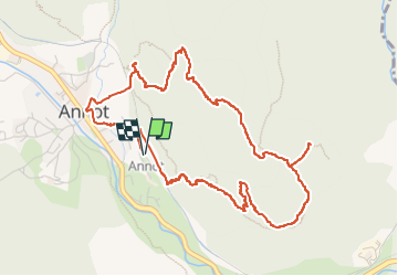

Length
6.3 km

Max alt
1038 m

Uphill gradient
378 m
Km-Effort
11.3 km

Min alt
689 m

Downhill gradient
378 m
Boucle
Yes
Creation date :
2024-11-25 08:22:08.041
Updated on :
2024-11-25 08:35:01.53
2h34
Difficulty : Easy

FREE GPS app for hiking
 SityTrail
IGN / Geographical institutes
SityTrail Plus
The world is yours!
About
Trail On foot of 6.3 km to be discovered at Provence-Alpes-Côte d'Azur, Alpes-de-Haute-Provence, Annot. This trail is proposed by vincente204.
Description
facile
Positioning
Country:
France
Region :
Provence-Alpes-Côte d'Azur
Department/Province :
Alpes-de-Haute-Provence
Municipality :
Annot
Location:
Unknown
Start:(Dec)
Start:(UTM)
313260 ; 4870480 (32T) N.
Comments