


aumône-Font Vive-Abeilles(14K 410D+)

kayamb
User
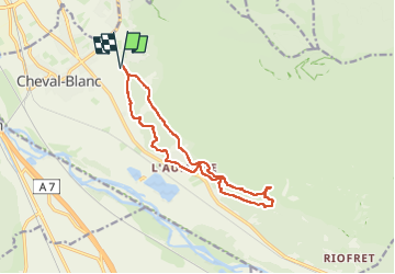

Length
13.9 km

Max alt
310 m

Uphill gradient
411 m
Km-Effort
19.4 km

Min alt
97 m

Downhill gradient
411 m
Boucle
Yes
Creation date :
2024-11-26 08:34:55.0
Updated on :
2024-11-26 10:43:25.132
2h02
Difficulty : Medium

FREE GPS app for hiking
 SityTrail
IGN / Geographical institutes
SityTrail Plus
The world is yours!
About
Trail Trail of 13.9 km to be discovered at Provence-Alpes-Côte d'Azur, Vaucluse, Cheval-Blanc. This trail is proposed by kayamb.
Positioning
Country:
France
Region :
Provence-Alpes-Côte d'Azur
Department/Province :
Vaucluse
Municipality :
Cheval-Blanc
Location:
Unknown
Start:(Dec)
Start:(UTM)
667596 ; 4852186 (31T) N.
Comments