


Caf Ambleteuse 2

reneperrin
User
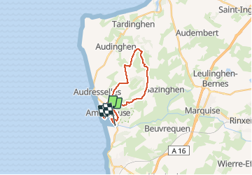

Length
15.6 km

Max alt
118 m

Uphill gradient
195 m
Km-Effort
18.2 km

Min alt
7 m

Downhill gradient
194 m
Boucle
No
Creation date :
2015-05-31 00:00:00.0
Updated on :
2015-05-31 00:00:00.0
3h43
Difficulty : Easy

FREE GPS app for hiking
 SityTrail
IGN / Geographical institutes
SityTrail Plus
The world is yours!
About
Trail Walking of 15.6 km to be discovered at Hauts-de-France, Pas-de-Calais, Ambleteuse. This trail is proposed by reneperrin.
Description
Rando pm
Positioning
Country:
France
Region :
Hauts-de-France
Department/Province :
Pas-de-Calais
Municipality :
Ambleteuse
Location:
Unknown
Start:(Dec)
Start:(UTM)
401618 ; 5629422 (31U) N.
Comments