


dd-matin

RANDOH
User

Length
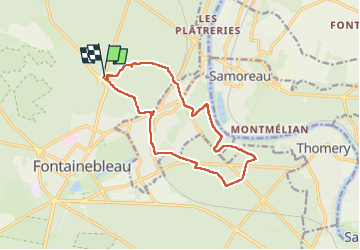
13.6 km

Max alt
162 m

Uphill gradient
251 m
Km-Effort
17 km

Min alt
54 m

Downhill gradient
246 m
Boucle
Yes
Creation date :
2024-11-28 08:47:05.554
Updated on :
2024-11-28 12:04:45.775
3h16
Difficulty : Easy

FREE GPS app for hiking
 SityTrail
IGN / Geographical institutes
SityTrail Plus
The world is yours!
About
Trail Walking of 13.6 km to be discovered at Ile-de-France, Seine-et-Marne, Fontainebleau. This trail is proposed by RANDOH.

Positioning
Country:
France
Region :
Ile-de-France
Department/Province :
Seine-et-Marne
Municipality :
Fontainebleau
Location:
Unknown
Start:(Dec)
Start:(UTM)
478490 ; 5363592 (31U) N.
Comments