


dd-après midi

RANDOH
User
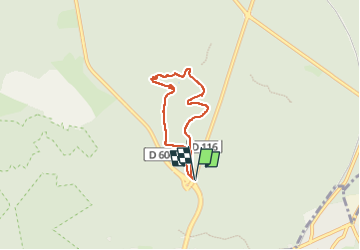

Length
4.8 km

Max alt
153 m

Uphill gradient
61 m
Km-Effort
5.7 km

Min alt
121 m

Downhill gradient
60 m
Boucle
Yes
Creation date :
2024-11-28 13:40:11.617
Updated on :
2024-11-28 14:59:51.549
1h19
Difficulty : Easy

FREE GPS app for hiking
 SityTrail
IGN / Geographical institutes
SityTrail Plus
The world is yours!
About
Trail Walking of 4.8 km to be discovered at Ile-de-France, Seine-et-Marne, Fontainebleau. This trail is proposed by RANDOH.
Positioning
Country:
France
Region :
Ile-de-France
Department/Province :
Seine-et-Marne
Municipality :
Fontainebleau
Location:
Unknown
Start:(Dec)
Start:(UTM)
478494 ; 5363595 (31U) N.
Comments