


labastide des fonts

lablaquiere
User
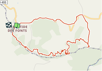

Length
7.3 km

Max alt
831 m

Uphill gradient
216 m
Km-Effort
10.2 km

Min alt
736 m

Downhill gradient
216 m
Boucle
Yes
Creation date :
2024-11-28 13:30:10.79
Updated on :
2024-11-28 16:28:57.951
2h05
Difficulty : Medium

FREE GPS app for hiking
 SityTrail
IGN / Geographical institutes
SityTrail Plus
The world is yours!
About
Trail Walking of 7.3 km to be discovered at Occitania, Aveyron, Cornus. This trail is proposed by lablaquiere.
Positioning
Country:
France
Region :
Occitania
Department/Province :
Aveyron
Municipality :
Cornus
Location:
Unknown
Start:(Dec)
Start:(UTM)
516596 ; 4853263 (31T) N.
Comments