


2025 Traversée du Chablais Jour4

staubalex
User
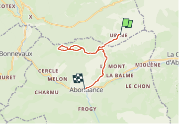

Length
10.3 km

Max alt
1805 m

Uphill gradient
406 m
Km-Effort
17.7 km

Min alt
925 m

Downhill gradient
978 m
Boucle
No
Creation date :
2024-11-28 23:31:30.735
Updated on :
2024-11-28 23:32:14.751
4h00
Difficulty : Difficult

FREE GPS app for hiking
 SityTrail
IGN / Geographical institutes
SityTrail Plus
The world is yours!
About
Trail Walking of 10.3 km to be discovered at Auvergne-Rhône-Alpes, Upper Savoy, Vacheresse. This trail is proposed by staubalex.
Positioning
Country:
France
Region :
Auvergne-Rhône-Alpes
Department/Province :
Upper Savoy
Municipality :
Vacheresse
Location:
Unknown
Start:(Dec)
Start:(UTM)
326235 ; 5130634 (32T) N.
Comments