


29/11/2023 - Douarnenez ouest.Virtuel

babeth35
User

Length
14 km

Max alt
82 m

Uphill gradient
258 m
Km-Effort
17.4 km

Min alt
0 m

Downhill gradient
252 m
Boucle
Yes
Creation date :
2024-11-29 12:37:29.655
Updated on :
2024-11-29 12:46:30.045
3h57
Difficulty : Easy
3h57
Difficulty : Difficult

FREE GPS app for hiking
 SityTrail
IGN / Geographical institutes
SityTrail Plus
The world is yours!
About
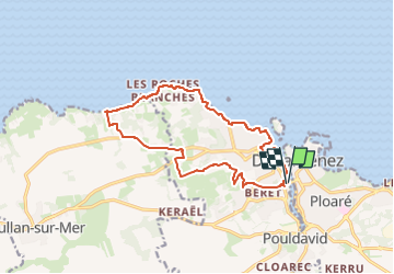
Trail On foot of 14 km to be discovered at Brittany, Finistère, Douarnenez. This trail is proposed by babeth35.
Positioning
Country:
France
Region :
Brittany
Department/Province :
Finistère
Municipality :
Douarnenez
Location:
Unknown
Start:(Dec)
Start:(UTM)
400639 ; 5327130 (30U) N.
Comments