


Saint sauveur

Daniel.BRUN-PICARD
User
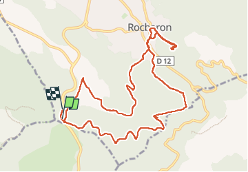

Length
13.1 km

Max alt
533 m

Uphill gradient
429 m
Km-Effort
18.9 km

Min alt
339 m

Downhill gradient
444 m
Boucle
Yes
Creation date :
2024-11-10 08:33:55.614
Updated on :
2024-11-30 07:14:52.141
6h27
Difficulty : Medium

FREE GPS app for hiking
 SityTrail
IGN / Geographical institutes
SityTrail Plus
The world is yours!
About
Trail Walking of 13.1 km to be discovered at Provence-Alpes-Côte d'Azur, Var, Rocbaron. This trail is proposed by Daniel.BRUN-PICARD.
Positioning
Country:
France
Region :
Provence-Alpes-Côte d'Azur
Department/Province :
Var
Municipality :
Rocbaron
Location:
Unknown
Start:(Dec)
Start:(UTM)
262230 ; 4796887 (32T) N.
Comments