


Vercors Roybon

c.gourme
User
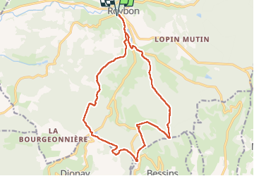

Length
18.4 km

Max alt
659 m

Uphill gradient
307 m
Km-Effort
22 km

Min alt
501 m

Downhill gradient
307 m
Boucle
Yes
Creation date :
2024-11-30 08:12:42.0
Updated on :
2024-11-30 14:34:15.842
5h34
Difficulty : Easy

FREE GPS app for hiking
 SityTrail
IGN / Geographical institutes
SityTrail Plus
The world is yours!
About
Trail Walking of 18.4 km to be discovered at Auvergne-Rhône-Alpes, Isère, Roybon. This trail is proposed by c.gourme.
Positioning
Country:
France
Region :
Auvergne-Rhône-Alpes
Department/Province :
Isère
Municipality :
Roybon
Location:
Unknown
Start:(Dec)
Start:(UTM)
675842 ; 5014009 (31T) N.
Comments