


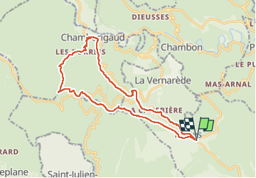
Portes Chambaurigaud

Pierre VASSEUR
User

Length
18.1 km

Max alt
634 m

Uphill gradient
591 m
Km-Effort
26 km

Min alt
297 m

Downhill gradient
592 m
Boucle
Yes
Creation date :
2024-11-30 08:40:44.703
Updated on :
2024-11-30 14:54:30.165
4h33
Difficulty : Medium

FREE GPS app for hiking
 SityTrail
IGN / Geographical institutes
SityTrail Plus
The world is yours!
About
Trail Walking of 18.1 km to be discovered at Occitania, Gard, Portes. This trail is proposed by Pierre VASSEUR.
Positioning
Country:
France
Region :
Occitania
Department/Province :
Gard
Municipality :
Portes
Location:
Unknown
Start:(Dec)
Start:(UTM)
581810 ; 4902173 (31T) N.
Comments