


villehervier

levequejef
User
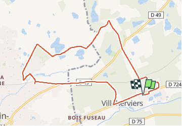

Length
10.3 km

Max alt
110 m

Uphill gradient
84 m
Km-Effort
11.5 km

Min alt
90 m

Downhill gradient
83 m
Boucle
Yes
Creation date :
2024-12-01 08:31:13.277
Updated on :
2024-12-01 09:53:16.948
1h21
Difficulty : Very easy

FREE GPS app for hiking
 SityTrail
IGN / Geographical institutes
SityTrail Plus
The world is yours!
About
Trail Running of 10.3 km to be discovered at Centre-Loire Valley, Loir-et-Cher, Villeherviers. This trail is proposed by levequejef.
Positioning
Country:
France
Region :
Centre-Loire Valley
Department/Province :
Loir-et-Cher
Municipality :
Villeherviers
Location:
Unknown
Start:(Dec)
Start:(UTM)
409210 ; 5246449 (31T) N.
Comments