


Montchenu 10 kms

Charignon
User
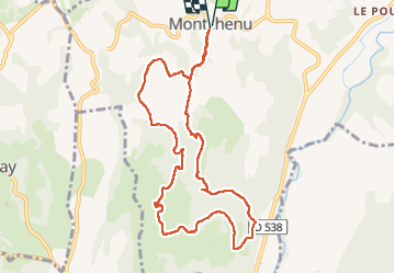

Length
10.1 km

Max alt
385 m

Uphill gradient
268 m
Km-Effort
13.7 km

Min alt
289 m

Downhill gradient
271 m
Boucle
Yes
Creation date :
2024-12-02 12:00:35.252
Updated on :
2024-12-02 15:17:17.195
3h16
Difficulty : Easy

FREE GPS app for hiking
 SityTrail
IGN / Geographical institutes
SityTrail Plus
The world is yours!
About
Trail Walking of 10.1 km to be discovered at Auvergne-Rhône-Alpes, Drôme, Montchenu. This trail is proposed by Charignon.
Positioning
Country:
France
Region :
Auvergne-Rhône-Alpes
Department/Province :
Drôme
Municipality :
Montchenu
Location:
Unknown
Start:(Dec)
Start:(UTM)
659594 ; 5006662 (31T) N.
Comments