


SityTrail - MASSINGIENNE RANDO 13 KM

djeepee74
User
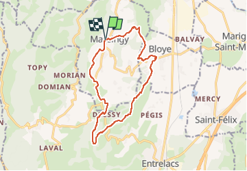

Length
14 km

Max alt
693 m

Uphill gradient
429 m
Km-Effort
19.7 km

Min alt
374 m

Downhill gradient
429 m
Boucle
Yes
Creation date :
2024-12-02 18:41:15.604
Updated on :
2024-12-02 18:46:34.723
4h15
Difficulty : Medium

FREE GPS app for hiking
 SityTrail
IGN / Geographical institutes
SityTrail Plus
The world is yours!
About
Trail Walking of 14 km to be discovered at Auvergne-Rhône-Alpes, Upper Savoy, Massingy. This trail is proposed by djeepee74.
Description
Origine: cailloux74
Positioning
Country:
France
Region :
Auvergne-Rhône-Alpes
Department/Province :
Upper Savoy
Municipality :
Massingy
Location:
Unknown
Start:(Dec)
Start:(UTM)
726646 ; 5079207 (31T) N.
Comments