


2024-11-10_23h21m30_exp_Le grand Ruy - Vesc

collot
User
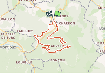

Length
17.2 km

Max alt
1074 m

Uphill gradient
718 m
Km-Effort
27 km

Min alt
512 m

Downhill gradient
718 m
Boucle
Yes
Creation date :
2024-11-10 22:21:30.373
Updated on :
2025-03-23 10:31:21.281
6h04
Difficulty : Medium

FREE GPS app for hiking
 SityTrail
IGN / Geographical institutes
SityTrail Plus
The world is yours!
About
Trail Walking of 17.2 km to be discovered at Auvergne-Rhône-Alpes, Drôme, Vesc. This trail is proposed by collot.
Description
Randonnée sympathique, mais pas transcendante ! Peu de lieux pour les pic-nic !
Positioning
Country:
France
Region :
Auvergne-Rhône-Alpes
Department/Province :
Drôme
Municipality :
Vesc
Location:
Unknown
Start:(Dec)
Start:(UTM)
670949 ; 4932163 (31T) N.
Comments