


venoymim

elilil
User
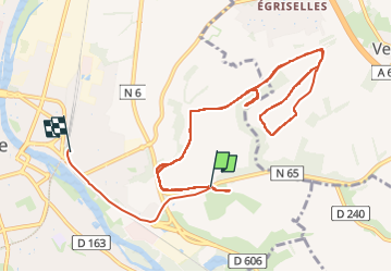

Length
13.2 km

Max alt
208 m

Uphill gradient
197 m
Km-Effort
15.9 km

Min alt
98 m

Downhill gradient
212 m
Boucle
No
Creation date :
2024-12-03 13:06:02.088
Updated on :
2024-12-03 16:01:14.319
2h54
Difficulty : Difficult

FREE GPS app for hiking
 SityTrail
IGN / Geographical institutes
SityTrail Plus
The world is yours!
About
Trail Walking of 13.2 km to be discovered at Bourgogne-Franche-Comté, Yonne, Auxerre. This trail is proposed by elilil.
Description
ok
Positioning
Country:
France
Region :
Bourgogne-Franche-Comté
Department/Province :
Yonne
Municipality :
Auxerre
Location:
Unknown
Start:(Dec)
Start:(UTM)
545513 ; 5293331 (31T) N.
Comments