


col de l'arc

Liebeaux
User
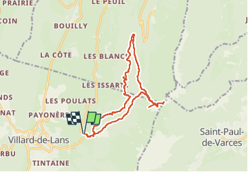

Length
16.3 km

Max alt
1742 m

Uphill gradient
799 m
Km-Effort
27 km

Min alt
1091 m

Downhill gradient
800 m
Boucle
Yes
Creation date :
2024-12-05 07:50:50.042
Updated on :
2024-12-05 15:07:05.429
7h15
Difficulty : Very difficult

FREE GPS app for hiking
 SityTrail
IGN / Geographical institutes
SityTrail Plus
The world is yours!
About
Trail Walking of 16.3 km to be discovered at Auvergne-Rhône-Alpes, Isère, Villard-de-Lans. This trail is proposed by Liebeaux.
Positioning
Country:
France
Region :
Auvergne-Rhône-Alpes
Department/Province :
Isère
Municipality :
Villard-de-Lans
Location:
Unknown
Start:(Dec)
Start:(UTM)
702612 ; 4994259 (31T) N.
Comments