


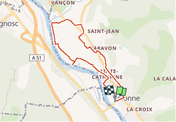
VOLONNE . SAINTE CATHERI.E O L

RobinMicheline
User GUIDE

Length
8.3 km

Max alt
468 m

Uphill gradient
73 m
Km-Effort
9.3 km

Min alt
433 m

Downhill gradient
71 m
Boucle
Yes
Creation date :
2024-12-05 12:30:09.787
Updated on :
2024-12-05 15:09:20.864
2h17
Difficulty : Medium

FREE GPS app for hiking
 SityTrail
IGN / Geographical institutes
SityTrail Plus
The world is yours!
About
Trail Walking of 8.3 km to be discovered at Provence-Alpes-Côte d'Azur, Alpes-de-Haute-Provence, Volonne. This trail is proposed by RobinMicheline.
Positioning
Country:
France
Region :
Provence-Alpes-Côte d'Azur
Department/Province :
Alpes-de-Haute-Provence
Municipality :
Volonne
Location:
Unknown
Start:(Dec)
Start:(UTM)
260655 ; 4888392 (32T) N.
Comments