


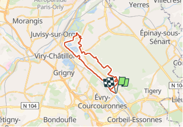
Étiolles bis rando

Genevieve Caisson
User

Length
23 km

Max alt
96 m

Uphill gradient
214 m
Km-Effort
26 km

Min alt
27 m

Downhill gradient
218 m
Boucle
Yes
Creation date :
2024-11-26 07:46:25.0
Updated on :
2024-12-06 07:59:59.045
6h20
Difficulty : Unknown

FREE GPS app for hiking
 SityTrail
IGN / Geographical institutes
SityTrail Plus
The world is yours!
About
Trail Walking of 23 km to be discovered at Ile-de-France, Essonne, Étiolles. This trail is proposed by Genevieve Caisson.
Positioning
Country:
France
Region :
Ile-de-France
Department/Province :
Essonne
Municipality :
Étiolles
Location:
Unknown
Start:(Dec)
Start:(UTM)
460019 ; 5387290 (31U) N.
Comments