


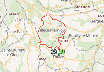
Theizé, Jarnioux, St Clair, St Abram, Les Fontaines, Le Bancillon

Mariolebeno
User

Length
14.3 km

Max alt
650 m

Uphill gradient
497 m
Km-Effort
21 km

Min alt
315 m

Downhill gradient
496 m
Boucle
Yes
Creation date :
2024-12-06 09:18:38.496
Updated on :
2024-12-09 08:21:27.725
4h44
Difficulty : Very difficult

FREE GPS app for hiking
 SityTrail
IGN / Geographical institutes
SityTrail Plus
The world is yours!
About
Trail Walking of 14.3 km to be discovered at Auvergne-Rhône-Alpes, Rhône, Theizé. This trail is proposed by Mariolebeno.
Positioning
Country:
France
Region :
Auvergne-Rhône-Alpes
Department/Province :
Rhône
Municipality :
Theizé
Location:
Unknown
Start:(Dec)
Start:(UTM)
625241 ; 5088555 (31T) N.
Comments