


2024-12-10 Le Vésinet, entre Seine, lacs, pelouses et rivière

Rando MLC
User
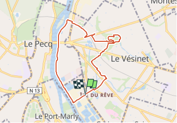

Length
8 km

Max alt
40 m

Uphill gradient
44 m
Km-Effort
8.6 km

Min alt
20 m

Downhill gradient
45 m
Boucle
Yes
Creation date :
2024-12-06 15:51:03.297
Updated on :
2024-12-07 08:15:50.971
1h56
Difficulty : Medium

FREE GPS app for hiking
 SityTrail
IGN / Geographical institutes
SityTrail Plus
The world is yours!
About
Trail Walking of 8 km to be discovered at Ile-de-France, Yvelines, Croissy-sur-Seine. This trail is proposed by Rando MLC.
Positioning
Country:
France
Region :
Ile-de-France
Department/Province :
Yvelines
Municipality :
Croissy-sur-Seine
Location:
Unknown
Start:(Dec)
Start:(UTM)
435430 ; 5415149 (31U) N.
Comments