


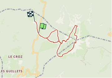
Chamechaude par le Pas de l'Arche

Luc Saint-guillain
User

Length
7.6 km

Max alt
2040 m

Uphill gradient
816 m
Km-Effort
18.5 km

Min alt
1327 m

Downhill gradient
816 m
Boucle
No
Creation date :
2024-12-08 14:32:20.252
Updated on :
2024-12-08 14:34:55.315
4h12
Difficulty : Medium

FREE GPS app for hiking
 SityTrail
IGN / Geographical institutes
SityTrail Plus
The world is yours!
About
Trail Walking of 7.6 km to be discovered at Auvergne-Rhône-Alpes, Isère, Sarcenas. This trail is proposed by Luc Saint-guillain.
Description
Départ : arrêt de bus Col de Porte. Descente par sangle côté Jardin, puis "chemin normal".
Positioning
Country:
France
Region :
Auvergne-Rhône-Alpes
Department/Province :
Isère
Municipality :
Sarcenas
Location:
Unknown
Start:(Dec)
Start:(UTM)
716987 ; 5018885 (31T) N.
Comments