


vers2

maxEA65
User
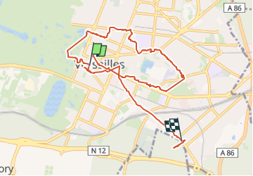

Length
10.4 km

Max alt
165 m

Uphill gradient
115 m
Km-Effort
11.9 km

Min alt
122 m

Downhill gradient
105 m
Boucle
No
Creation date :
2024-12-09 13:30:13.115
Updated on :
2024-12-09 15:23:13.616
1h52
Difficulty : Medium

FREE GPS app for hiking
 SityTrail
IGN / Geographical institutes
SityTrail Plus
The world is yours!
About
Trail Walking of 10.4 km to be discovered at Ile-de-France, Yvelines, Versailles. This trail is proposed by maxEA65.
Positioning
Country:
France
Region :
Ile-de-France
Department/Province :
Yvelines
Municipality :
Versailles
Location:
Unknown
Start:(Dec)
Start:(UTM)
435695 ; 5405956 (31U) N.
Comments