


maredsous

claude.warnon
User
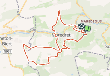

Length
11.2 km

Max alt
283 m

Uphill gradient
291 m
Km-Effort
15.1 km

Min alt
171 m

Downhill gradient
296 m
Boucle
Yes
Creation date :
2024-12-09 12:59:55.721
Updated on :
2024-12-09 16:06:13.862
2h25
Difficulty : Difficult

FREE GPS app for hiking
 SityTrail
IGN / Geographical institutes
SityTrail Plus
The world is yours!
About
Trail Walking of 11.2 km to be discovered at Wallonia, Namur, Anhée. This trail is proposed by claude.warnon.
Description
rando 10km départ abbaye maredsous
Positioning
Country:
Belgium
Region :
Wallonia
Department/Province :
Namur
Municipality :
Anhée
Location:
Unknown
Start:(Dec)
Start:(UTM)
625714 ; 5573435 (31U) N.
Comments