


tavaux

cmike39
User
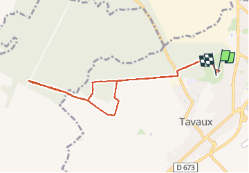

Length
9.6 km

Max alt
204 m

Uphill gradient
73 m
Km-Effort
10.5 km

Min alt
186 m

Downhill gradient
73 m
Boucle
Yes
Creation date :
2024-12-10 08:05:14.042
Updated on :
2024-12-10 10:33:54.879
2h27
Difficulty : Very easy

FREE GPS app for hiking
 SityTrail
IGN / Geographical institutes
SityTrail Plus
The world is yours!
About
Trail Nordic walking of 9.6 km to be discovered at Bourgogne-Franche-Comté, Jura, Tavaux. This trail is proposed by cmike39.
Positioning
Country:
France
Region :
Bourgogne-Franche-Comté
Department/Province :
Jura
Municipality :
Tavaux
Location:
Unknown
Start:(Dec)
Start:(UTM)
682972 ; 5213027 (31T) N.
Comments