


Soum de l’Hailla

lebarça
User
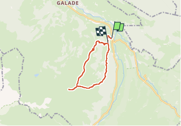

Length
10.3 km

Max alt
1883 m

Uphill gradient
1042 m
Km-Effort
24 km

Min alt
859 m

Downhill gradient
960 m
Boucle
No
Creation date :
2024-12-11 08:07:22.0
Updated on :
2024-12-11 15:18:55.624

FREE GPS app for hiking
 SityTrail
IGN / Geographical institutes
SityTrail Plus
The world is yours!
About
Trail of 10.3 km to be discovered at Occitania, Hautespyrenees, Campan. This trail is proposed by lebarça.
Positioning
Country:
France
Region :
Occitania
Department/Province :
Hautespyrenees
Municipality :
Campan
Location:
Unknown
Start:(Dec)
Start:(UTM)
273895 ; 4762815 (31T) N.
Comments