


lieutenai

vincente204
User
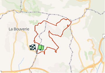

Length
18.4 km

Max alt
140 m

Uphill gradient
286 m
Km-Effort
22 km

Min alt
44 m

Downhill gradient
287 m
Boucle
Yes
Creation date :
2024-12-11 08:06:04.471
Updated on :
2024-12-11 15:36:31.035
7h14
Difficulty : Very difficult

FREE GPS app for hiking
 SityTrail
IGN / Geographical institutes
SityTrail Plus
The world is yours!
About
Trail Walking of 18.4 km to be discovered at Provence-Alpes-Côte d'Azur, Var, Puget-sur-Argens. This trail is proposed by vincente204.
Description
facile
Positioning
Country:
France
Region :
Provence-Alpes-Côte d'Azur
Department/Province :
Var
Municipality :
Puget-sur-Argens
Location:
Unknown
Start:(Dec)
Start:(UTM)
311221 ; 4816697 (32T) N.
Comments