


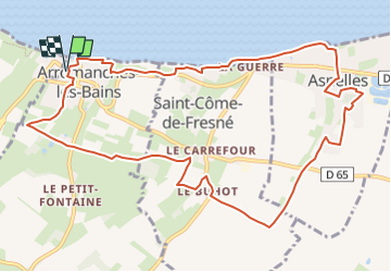
Arromanches

papylou7
User

Length
11.7 km

Max alt
58 m

Uphill gradient
169 m
Km-Effort
14 km

Min alt
0 m

Downhill gradient
169 m
Boucle
Yes
Creation date :
2024-12-12 15:36:30.0
Updated on :
2024-12-15 09:20:30.329
3h10
Difficulty : Difficult

FREE GPS app for hiking
 SityTrail
IGN / Geographical institutes
SityTrail Plus
The world is yours!
About
Trail Walking of 11.7 km to be discovered at Normandy, Calvados, Arromanches-les-Bains. This trail is proposed by papylou7.
Description
Parking gratuits Place Roland Toupotte
Positioning
Country:
France
Region :
Normandy
Department/Province :
Calvados
Municipality :
Arromanches-les-Bains
Location:
Unknown
Start:(Dec)
Start:(UTM)
672466 ; 5467885 (30U) N.
Comments