


l'Hopital Saint Jean. 29/05/2023-16873627

Gpoujade
User

Length
13.9 km

Max alt
339 m

Uphill gradient
349 m
Km-Effort
18.6 km

Min alt
224 m

Downhill gradient
350 m
Boucle
Yes
Creation date :
2024-12-13 14:24:35.598
Updated on :
2024-12-13 14:48:48.433
4h13
Difficulty : Difficult

FREE GPS app for hiking
 SityTrail
IGN / Geographical institutes
SityTrail Plus
The world is yours!
About
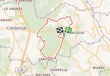
Trail Walking of 13.9 km to be discovered at Occitania, Lot, Cressensac-Sarrazac. This trail is proposed by Gpoujade.
Description
Boucle


Positioning
Country:
France
Region :
Occitania
Department/Province :
Lot
Municipality :
Cressensac-Sarrazac
Location:
Sarrazac
Start:(Dec)
Start:(UTM)
387728 ; 4985408 (31T) N.
Comments