


QUERCY ISSENDOLUS 2024 14.7Km D+ 166m-17905391-20394170

Gpoujade
User
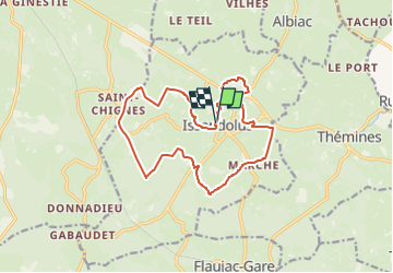

Length
15.3 km

Max alt
352 m

Uphill gradient
213 m
Km-Effort
18.1 km

Min alt
302 m

Downhill gradient
217 m
Boucle
Yes
Creation date :
2024-12-14 14:23:12.12
Updated on :
2025-03-15 10:26:25.403
4h07
Difficulty : Difficult

FREE GPS app for hiking
 SityTrail
IGN / Geographical institutes
SityTrail Plus
The world is yours!
About
Trail Walking of 15.3 km to be discovered at Occitania, Lot, Issendolus. This trail is proposed by Gpoujade.

Positioning
Country:
France
Region :
Occitania
Department/Province :
Lot
Municipality :
Issendolus
Location:
Unknown
Start:(Dec)
Start:(UTM)
403972 ; 4955107 (31T) N.
Comments