


la soufrière

claudel
User
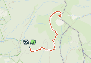

Length
7.6 km

Max alt
1455 m

Uphill gradient
537 m
Km-Effort
14.7 km

Min alt
915 m

Downhill gradient
537 m
Boucle
Yes
Creation date :
2024-12-14 12:58:42.654
Updated on :
2024-12-14 17:29:33.966
3h48
Difficulty : Difficult

FREE GPS app for hiking
 SityTrail
IGN / Geographical institutes
SityTrail Plus
The world is yours!
About
Trail Walking of 7.6 km to be discovered at Guadeloupe, Unknown, Saint-Claude. This trail is proposed by claudel.
Positioning
Country:
France
Region :
Guadeloupe
Department/Province :
Unknown
Municipality :
Saint-Claude
Location:
Unknown
Start:(Dec)
Start:(UTM)
641857 ; 1773234 (20Q) N.
Comments