


Vaugines - Cucuron

mhetpierre
User
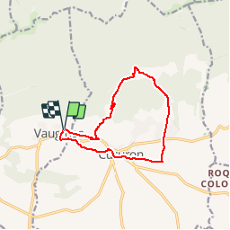

Length
12 km

Max alt
565 m

Uphill gradient
297 m
Km-Effort
15.9 km

Min alt
326 m

Downhill gradient
300 m
Boucle
Yes
Creation date :
2018-08-18 15:30:25.65
Updated on :
2018-08-18 15:30:25.65
3h26
Difficulty : Easy

FREE GPS app for hiking
 SityTrail
IGN / Geographical institutes
SityTrail Plus
The world is yours!
About
Trail Walking of 12 km to be discovered at Provence-Alpes-Côte d'Azur, Vaucluse, Vaugines. This trail is proposed by mhetpierre.
Positioning
Country:
France
Region :
Provence-Alpes-Côte d'Azur
Department/Province :
Vaucluse
Municipality :
Vaugines
Location:
Unknown
Start:(Dec)
Start:(UTM)
694516 ; 4850226 (31T) N.
Comments