


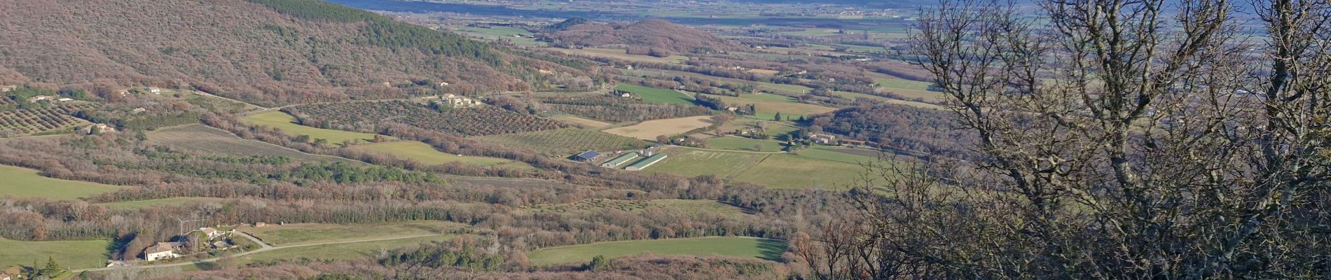
Condillac "Le Rocher de Ruas" 7km.

chancha
User GUIDE
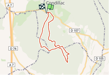

Length
7.1 km

Max alt
417 m

Uphill gradient
335 m
Km-Effort
11.6 km

Min alt
168 m

Downhill gradient
334 m
Boucle
Yes
Creation date :
2024-12-12 15:50:02.25
Updated on :
2024-12-17 09:46:59.524
2h38
Difficulty : Medium

FREE GPS app for hiking
 SityTrail
IGN / Geographical institutes
SityTrail Plus
The world is yours!
About
Trail Walking of 7.1 km to be discovered at Auvergne-Rhône-Alpes, Drôme, Condillac. This trail is proposed by chancha.
Description
Au départ du village de Condillac , grimpez jusqu'"a la crête du Ruas et profitez de la vue panoramique.Vous avez la possibilité de rallonger cette itinéraire en basculant du côté de Sauzet.
Photos
"
data-pinterest-text="Pin it"
data-tweet-text="share on twitter"
data-facebook-share-url="https://www.sitytrail.com/en/trails/4296769-condillac--condillac-xle-rocher-de-ruasx-7kmx/?photo=0#lg=1&slide=0"
data-twitter-share-url="https://www.sitytrail.com/en/trails/4296769-condillac--condillac-xle-rocher-de-ruasx-7kmx/?photo=0#lg=1&slide=0"
data-googleplus-share-url="https://www.sitytrail.com/en/trails/4296769-condillac--condillac-xle-rocher-de-ruasx-7kmx/?photo=0#lg=1&slide=0"
data-pinterest-share-url="https://www.sitytrail.com/en/trails/4296769-condillac--condillac-xle-rocher-de-ruasx-7kmx/?photo=0#lg=1&slide=0">
 "
data-pinterest-text="Pin it"
data-tweet-text="share on twitter"
data-facebook-share-url="https://www.sitytrail.com/en/trails/4296769-condillac--condillac-xle-rocher-de-ruasx-7kmx/?photo=1#lg=1&slide=1"
data-twitter-share-url="https://www.sitytrail.com/en/trails/4296769-condillac--condillac-xle-rocher-de-ruasx-7kmx/?photo=1#lg=1&slide=1"
data-googleplus-share-url="https://www.sitytrail.com/en/trails/4296769-condillac--condillac-xle-rocher-de-ruasx-7kmx/?photo=1#lg=1&slide=1"
data-pinterest-share-url="https://www.sitytrail.com/en/trails/4296769-condillac--condillac-xle-rocher-de-ruasx-7kmx/?photo=1#lg=1&slide=1">
"
data-pinterest-text="Pin it"
data-tweet-text="share on twitter"
data-facebook-share-url="https://www.sitytrail.com/en/trails/4296769-condillac--condillac-xle-rocher-de-ruasx-7kmx/?photo=1#lg=1&slide=1"
data-twitter-share-url="https://www.sitytrail.com/en/trails/4296769-condillac--condillac-xle-rocher-de-ruasx-7kmx/?photo=1#lg=1&slide=1"
data-googleplus-share-url="https://www.sitytrail.com/en/trails/4296769-condillac--condillac-xle-rocher-de-ruasx-7kmx/?photo=1#lg=1&slide=1"
data-pinterest-share-url="https://www.sitytrail.com/en/trails/4296769-condillac--condillac-xle-rocher-de-ruasx-7kmx/?photo=1#lg=1&slide=1">
 "
data-pinterest-text="Pin it"
data-tweet-text="share on twitter"
data-facebook-share-url="https://www.sitytrail.com/en/trails/4296769-condillac--condillac-xle-rocher-de-ruasx-7kmx/?photo=2#lg=1&slide=2"
data-twitter-share-url="https://www.sitytrail.com/en/trails/4296769-condillac--condillac-xle-rocher-de-ruasx-7kmx/?photo=2#lg=1&slide=2"
data-googleplus-share-url="https://www.sitytrail.com/en/trails/4296769-condillac--condillac-xle-rocher-de-ruasx-7kmx/?photo=2#lg=1&slide=2"
data-pinterest-share-url="https://www.sitytrail.com/en/trails/4296769-condillac--condillac-xle-rocher-de-ruasx-7kmx/?photo=2#lg=1&slide=2">
"
data-pinterest-text="Pin it"
data-tweet-text="share on twitter"
data-facebook-share-url="https://www.sitytrail.com/en/trails/4296769-condillac--condillac-xle-rocher-de-ruasx-7kmx/?photo=2#lg=1&slide=2"
data-twitter-share-url="https://www.sitytrail.com/en/trails/4296769-condillac--condillac-xle-rocher-de-ruasx-7kmx/?photo=2#lg=1&slide=2"
data-googleplus-share-url="https://www.sitytrail.com/en/trails/4296769-condillac--condillac-xle-rocher-de-ruasx-7kmx/?photo=2#lg=1&slide=2"
data-pinterest-share-url="https://www.sitytrail.com/en/trails/4296769-condillac--condillac-xle-rocher-de-ruasx-7kmx/?photo=2#lg=1&slide=2">
 "
data-pinterest-text="Pin it"
data-tweet-text="share on twitter"
data-facebook-share-url="https://www.sitytrail.com/en/trails/4296769-condillac--condillac-xle-rocher-de-ruasx-7kmx/?photo=3#lg=1&slide=3"
data-twitter-share-url="https://www.sitytrail.com/en/trails/4296769-condillac--condillac-xle-rocher-de-ruasx-7kmx/?photo=3#lg=1&slide=3"
data-googleplus-share-url="https://www.sitytrail.com/en/trails/4296769-condillac--condillac-xle-rocher-de-ruasx-7kmx/?photo=3#lg=1&slide=3"
data-pinterest-share-url="https://www.sitytrail.com/en/trails/4296769-condillac--condillac-xle-rocher-de-ruasx-7kmx/?photo=3#lg=1&slide=3">
"
data-pinterest-text="Pin it"
data-tweet-text="share on twitter"
data-facebook-share-url="https://www.sitytrail.com/en/trails/4296769-condillac--condillac-xle-rocher-de-ruasx-7kmx/?photo=3#lg=1&slide=3"
data-twitter-share-url="https://www.sitytrail.com/en/trails/4296769-condillac--condillac-xle-rocher-de-ruasx-7kmx/?photo=3#lg=1&slide=3"
data-googleplus-share-url="https://www.sitytrail.com/en/trails/4296769-condillac--condillac-xle-rocher-de-ruasx-7kmx/?photo=3#lg=1&slide=3"
data-pinterest-share-url="https://www.sitytrail.com/en/trails/4296769-condillac--condillac-xle-rocher-de-ruasx-7kmx/?photo=3#lg=1&slide=3">
 "
data-pinterest-text="Pin it"
data-tweet-text="share on twitter"
data-facebook-share-url="https://www.sitytrail.com/en/trails/4296769-condillac--condillac-xle-rocher-de-ruasx-7kmx/?photo=4#lg=1&slide=4"
data-twitter-share-url="https://www.sitytrail.com/en/trails/4296769-condillac--condillac-xle-rocher-de-ruasx-7kmx/?photo=4#lg=1&slide=4"
data-googleplus-share-url="https://www.sitytrail.com/en/trails/4296769-condillac--condillac-xle-rocher-de-ruasx-7kmx/?photo=4#lg=1&slide=4"
data-pinterest-share-url="https://www.sitytrail.com/en/trails/4296769-condillac--condillac-xle-rocher-de-ruasx-7kmx/?photo=4#lg=1&slide=4">
"
data-pinterest-text="Pin it"
data-tweet-text="share on twitter"
data-facebook-share-url="https://www.sitytrail.com/en/trails/4296769-condillac--condillac-xle-rocher-de-ruasx-7kmx/?photo=4#lg=1&slide=4"
data-twitter-share-url="https://www.sitytrail.com/en/trails/4296769-condillac--condillac-xle-rocher-de-ruasx-7kmx/?photo=4#lg=1&slide=4"
data-googleplus-share-url="https://www.sitytrail.com/en/trails/4296769-condillac--condillac-xle-rocher-de-ruasx-7kmx/?photo=4#lg=1&slide=4"
data-pinterest-share-url="https://www.sitytrail.com/en/trails/4296769-condillac--condillac-xle-rocher-de-ruasx-7kmx/?photo=4#lg=1&slide=4">
 "
data-pinterest-text="Pin it"
data-tweet-text="share on twitter"
data-facebook-share-url="https://www.sitytrail.com/en/trails/4296769-condillac--condillac-xle-rocher-de-ruasx-7kmx/?photo=5#lg=1&slide=5"
data-twitter-share-url="https://www.sitytrail.com/en/trails/4296769-condillac--condillac-xle-rocher-de-ruasx-7kmx/?photo=5#lg=1&slide=5"
data-googleplus-share-url="https://www.sitytrail.com/en/trails/4296769-condillac--condillac-xle-rocher-de-ruasx-7kmx/?photo=5#lg=1&slide=5"
data-pinterest-share-url="https://www.sitytrail.com/en/trails/4296769-condillac--condillac-xle-rocher-de-ruasx-7kmx/?photo=5#lg=1&slide=5">
"
data-pinterest-text="Pin it"
data-tweet-text="share on twitter"
data-facebook-share-url="https://www.sitytrail.com/en/trails/4296769-condillac--condillac-xle-rocher-de-ruasx-7kmx/?photo=5#lg=1&slide=5"
data-twitter-share-url="https://www.sitytrail.com/en/trails/4296769-condillac--condillac-xle-rocher-de-ruasx-7kmx/?photo=5#lg=1&slide=5"
data-googleplus-share-url="https://www.sitytrail.com/en/trails/4296769-condillac--condillac-xle-rocher-de-ruasx-7kmx/?photo=5#lg=1&slide=5"
data-pinterest-share-url="https://www.sitytrail.com/en/trails/4296769-condillac--condillac-xle-rocher-de-ruasx-7kmx/?photo=5#lg=1&slide=5">

 "
data-pinterest-text="Pin it"
data-tweet-text="share on twitter"
data-facebook-share-url="https://www.sitytrail.com/en/trails/4296769-condillac--condillac-xle-rocher-de-ruasx-7kmx/?photo=1#lg=1&slide=1"
data-twitter-share-url="https://www.sitytrail.com/en/trails/4296769-condillac--condillac-xle-rocher-de-ruasx-7kmx/?photo=1#lg=1&slide=1"
data-googleplus-share-url="https://www.sitytrail.com/en/trails/4296769-condillac--condillac-xle-rocher-de-ruasx-7kmx/?photo=1#lg=1&slide=1"
data-pinterest-share-url="https://www.sitytrail.com/en/trails/4296769-condillac--condillac-xle-rocher-de-ruasx-7kmx/?photo=1#lg=1&slide=1">
"
data-pinterest-text="Pin it"
data-tweet-text="share on twitter"
data-facebook-share-url="https://www.sitytrail.com/en/trails/4296769-condillac--condillac-xle-rocher-de-ruasx-7kmx/?photo=1#lg=1&slide=1"
data-twitter-share-url="https://www.sitytrail.com/en/trails/4296769-condillac--condillac-xle-rocher-de-ruasx-7kmx/?photo=1#lg=1&slide=1"
data-googleplus-share-url="https://www.sitytrail.com/en/trails/4296769-condillac--condillac-xle-rocher-de-ruasx-7kmx/?photo=1#lg=1&slide=1"
data-pinterest-share-url="https://www.sitytrail.com/en/trails/4296769-condillac--condillac-xle-rocher-de-ruasx-7kmx/?photo=1#lg=1&slide=1">
 "
data-pinterest-text="Pin it"
data-tweet-text="share on twitter"
data-facebook-share-url="https://www.sitytrail.com/en/trails/4296769-condillac--condillac-xle-rocher-de-ruasx-7kmx/?photo=2#lg=1&slide=2"
data-twitter-share-url="https://www.sitytrail.com/en/trails/4296769-condillac--condillac-xle-rocher-de-ruasx-7kmx/?photo=2#lg=1&slide=2"
data-googleplus-share-url="https://www.sitytrail.com/en/trails/4296769-condillac--condillac-xle-rocher-de-ruasx-7kmx/?photo=2#lg=1&slide=2"
data-pinterest-share-url="https://www.sitytrail.com/en/trails/4296769-condillac--condillac-xle-rocher-de-ruasx-7kmx/?photo=2#lg=1&slide=2">
"
data-pinterest-text="Pin it"
data-tweet-text="share on twitter"
data-facebook-share-url="https://www.sitytrail.com/en/trails/4296769-condillac--condillac-xle-rocher-de-ruasx-7kmx/?photo=2#lg=1&slide=2"
data-twitter-share-url="https://www.sitytrail.com/en/trails/4296769-condillac--condillac-xle-rocher-de-ruasx-7kmx/?photo=2#lg=1&slide=2"
data-googleplus-share-url="https://www.sitytrail.com/en/trails/4296769-condillac--condillac-xle-rocher-de-ruasx-7kmx/?photo=2#lg=1&slide=2"
data-pinterest-share-url="https://www.sitytrail.com/en/trails/4296769-condillac--condillac-xle-rocher-de-ruasx-7kmx/?photo=2#lg=1&slide=2">
 "
data-pinterest-text="Pin it"
data-tweet-text="share on twitter"
data-facebook-share-url="https://www.sitytrail.com/en/trails/4296769-condillac--condillac-xle-rocher-de-ruasx-7kmx/?photo=3#lg=1&slide=3"
data-twitter-share-url="https://www.sitytrail.com/en/trails/4296769-condillac--condillac-xle-rocher-de-ruasx-7kmx/?photo=3#lg=1&slide=3"
data-googleplus-share-url="https://www.sitytrail.com/en/trails/4296769-condillac--condillac-xle-rocher-de-ruasx-7kmx/?photo=3#lg=1&slide=3"
data-pinterest-share-url="https://www.sitytrail.com/en/trails/4296769-condillac--condillac-xle-rocher-de-ruasx-7kmx/?photo=3#lg=1&slide=3">
"
data-pinterest-text="Pin it"
data-tweet-text="share on twitter"
data-facebook-share-url="https://www.sitytrail.com/en/trails/4296769-condillac--condillac-xle-rocher-de-ruasx-7kmx/?photo=3#lg=1&slide=3"
data-twitter-share-url="https://www.sitytrail.com/en/trails/4296769-condillac--condillac-xle-rocher-de-ruasx-7kmx/?photo=3#lg=1&slide=3"
data-googleplus-share-url="https://www.sitytrail.com/en/trails/4296769-condillac--condillac-xle-rocher-de-ruasx-7kmx/?photo=3#lg=1&slide=3"
data-pinterest-share-url="https://www.sitytrail.com/en/trails/4296769-condillac--condillac-xle-rocher-de-ruasx-7kmx/?photo=3#lg=1&slide=3">
 "
data-pinterest-text="Pin it"
data-tweet-text="share on twitter"
data-facebook-share-url="https://www.sitytrail.com/en/trails/4296769-condillac--condillac-xle-rocher-de-ruasx-7kmx/?photo=4#lg=1&slide=4"
data-twitter-share-url="https://www.sitytrail.com/en/trails/4296769-condillac--condillac-xle-rocher-de-ruasx-7kmx/?photo=4#lg=1&slide=4"
data-googleplus-share-url="https://www.sitytrail.com/en/trails/4296769-condillac--condillac-xle-rocher-de-ruasx-7kmx/?photo=4#lg=1&slide=4"
data-pinterest-share-url="https://www.sitytrail.com/en/trails/4296769-condillac--condillac-xle-rocher-de-ruasx-7kmx/?photo=4#lg=1&slide=4">
"
data-pinterest-text="Pin it"
data-tweet-text="share on twitter"
data-facebook-share-url="https://www.sitytrail.com/en/trails/4296769-condillac--condillac-xle-rocher-de-ruasx-7kmx/?photo=4#lg=1&slide=4"
data-twitter-share-url="https://www.sitytrail.com/en/trails/4296769-condillac--condillac-xle-rocher-de-ruasx-7kmx/?photo=4#lg=1&slide=4"
data-googleplus-share-url="https://www.sitytrail.com/en/trails/4296769-condillac--condillac-xle-rocher-de-ruasx-7kmx/?photo=4#lg=1&slide=4"
data-pinterest-share-url="https://www.sitytrail.com/en/trails/4296769-condillac--condillac-xle-rocher-de-ruasx-7kmx/?photo=4#lg=1&slide=4">
 "
data-pinterest-text="Pin it"
data-tweet-text="share on twitter"
data-facebook-share-url="https://www.sitytrail.com/en/trails/4296769-condillac--condillac-xle-rocher-de-ruasx-7kmx/?photo=5#lg=1&slide=5"
data-twitter-share-url="https://www.sitytrail.com/en/trails/4296769-condillac--condillac-xle-rocher-de-ruasx-7kmx/?photo=5#lg=1&slide=5"
data-googleplus-share-url="https://www.sitytrail.com/en/trails/4296769-condillac--condillac-xle-rocher-de-ruasx-7kmx/?photo=5#lg=1&slide=5"
data-pinterest-share-url="https://www.sitytrail.com/en/trails/4296769-condillac--condillac-xle-rocher-de-ruasx-7kmx/?photo=5#lg=1&slide=5">
"
data-pinterest-text="Pin it"
data-tweet-text="share on twitter"
data-facebook-share-url="https://www.sitytrail.com/en/trails/4296769-condillac--condillac-xle-rocher-de-ruasx-7kmx/?photo=5#lg=1&slide=5"
data-twitter-share-url="https://www.sitytrail.com/en/trails/4296769-condillac--condillac-xle-rocher-de-ruasx-7kmx/?photo=5#lg=1&slide=5"
data-googleplus-share-url="https://www.sitytrail.com/en/trails/4296769-condillac--condillac-xle-rocher-de-ruasx-7kmx/?photo=5#lg=1&slide=5"
data-pinterest-share-url="https://www.sitytrail.com/en/trails/4296769-condillac--condillac-xle-rocher-de-ruasx-7kmx/?photo=5#lg=1&slide=5">

Positioning
Country:
France
Region :
Auvergne-Rhône-Alpes
Department/Province :
Drôme
Municipality :
Condillac
Location:
Unknown
Start:(Dec)
Start:(UTM)
643760 ; 4944301 (31T) N.
Comments