


3 oct. 2020 10:23:19 hortus

gadafo
User

Length
11.3 km

Max alt
500 m

Uphill gradient
461 m
Km-Effort
17.5 km

Min alt
183 m

Downhill gradient
460 m
Boucle
Yes
Creation date :
2024-12-16 13:41:27.299
Updated on :
2024-12-16 13:44:00.019
3h58
Difficulty : Difficult

FREE GPS app for hiking
 SityTrail
IGN / Geographical institutes
SityTrail Plus
The world is yours!
About
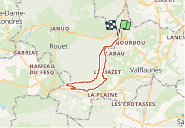
Trail Walking of 11.3 km to be discovered at Occitania, Hérault, Rouet. This trail is proposed by gadafo.
Positioning
Country:
France
Region :
Occitania
Department/Province :
Hérault
Municipality :
Rouet
Location:
Unknown
Start:(Dec)
Start:(UTM)
568609 ; 4851846 (31T) N.
Comments
belle randonnée il faut avoir le pied montagnard car beaucoup de rocher sur les crêtes.