


Fleurie (15 km - D. 446 m)

Thomasdanielle
User
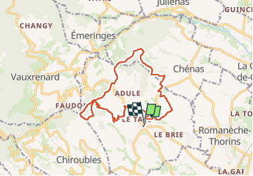

Length
15.3 km

Max alt
521 m

Uphill gradient
446 m
Km-Effort
21 km

Min alt
269 m

Downhill gradient
448 m
Boucle
Yes
Creation date :
2024-12-16 08:16:48.0
Updated on :
2025-02-26 13:02:01.995
4h49
Difficulty : Difficult

FREE GPS app for hiking
 SityTrail
IGN / Geographical institutes
SityTrail Plus
The world is yours!
About
Trail Walking of 15.3 km to be discovered at Auvergne-Rhône-Alpes, Rhône, Fleurie. This trail is proposed by Thomasdanielle.
Description
D.A : Parking de l'église
Positioning
Country:
France
Region :
Auvergne-Rhône-Alpes
Department/Province :
Rhône
Municipality :
Fleurie
Location:
Unknown
Start:(Dec)
Start:(UTM)
630936 ; 5116834 (31T) N.
Comments