


Tête de Fouran par le ravin du Clot

orsel
User GUIDE
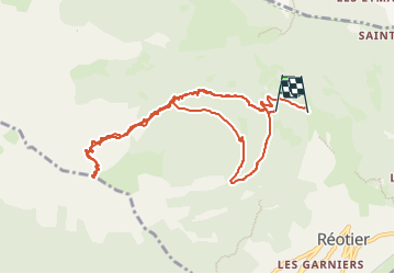

Length
10.3 km

Max alt
2450 m

Uphill gradient
848 m
Km-Effort
22 km

Min alt
1497 m

Downhill gradient
948 m
Boucle
No
Creation date :
2024-12-16 07:57:13.6
Updated on :
2024-12-16 17:13:04.398
5h02
Difficulty : Medium

FREE GPS app for hiking
 SityTrail
IGN / Geographical institutes
SityTrail Plus
The world is yours!
About
Trail Touring skiing of 10.3 km to be discovered at Provence-Alpes-Côte d'Azur, Hautes-Alpes, Réotier. This trail is proposed by orsel.
Positioning
Country:
France
Region :
Provence-Alpes-Côte d'Azur
Department/Province :
Hautes-Alpes
Municipality :
Réotier
Location:
Unknown
Start:(Dec)
Start:(UTM)
308072 ; 4950306 (32T) N.
Comments