


08-ChandolasBoisdeChabanet

ganinette
User
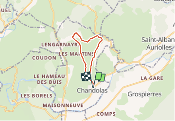

Length
8.6 km
Boucle
Yes
Creation date :
2024-12-18 08:17:54.005
Updated on :
2024-12-18 08:17:54.005
--
Difficulty : Unknown

FREE GPS app for hiking
 SityTrail
IGN / Geographical institutes
SityTrail Plus
The world is yours!
About
Trail Walking of 8.6 km to be discovered at Auvergne-Rhône-Alpes, Ardèche, Chandolas. This trail is proposed by ganinette.
Positioning
Country:
France
Region :
Auvergne-Rhône-Alpes
Department/Province :
Ardèche
Municipality :
Chandolas
Location:
Unknown
Start:(Dec)
Start:(UTM)
599816 ; 4917459 (31T) N.
Comments